LABEL: 2012.323 de LETH
By Ineke Dane Geraldine Kirrihi Barlow
February 2024
For European maritime nations of the seventeenth and eighteenth centuries, mapping and navigation were central to their political and economic power.
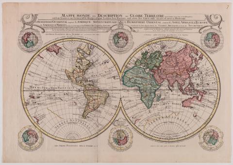
Mappe Monde ou Déscription du Globe Terrestre is an engraved, hand-coloured, twin hemispherical map surrounded by six smaller spheres. It amalgamates and builds upon cartographic observations made by two centuries of explorers, from Magellan in 1520 through to those from the late 1730s. While this map boasts a large portion of the world as ‘discovered’, absence is equally instructive. North America is missing much of its Pacific West Coast and Australia its east coast, while New Zealand is barely touched upon.
Hendrik de Leth was a Dutch engraver, publisher and painter, active in Amsterdam in the eighteenth century. He worked for the Visscher family, who were held in high esteem as art dealers and map publishers in the city at the time. De Leth’s contribution to cartography expanded much more ancient forms of mapping as communication. Maps across the ages have been used as a means of understanding and summarising the universal — a graphic synthesis of science and culture.
Connected objects
Metadata, copyright and sharing information
About this story
- Subject
